- Home
- »
- IRS Products
- »
- Euro-Maps 2D
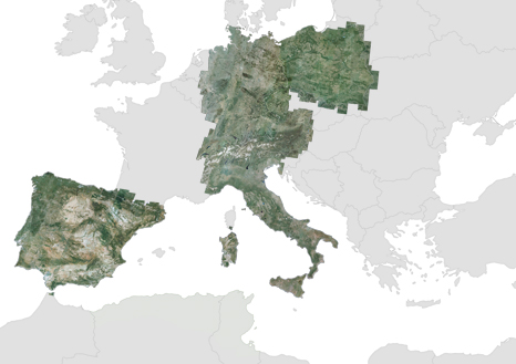
Euro-Maps 2D
Euro-Maps 2D are 5 m natural colour ortho-mosaics which are an ideal basis for the production of planning-relevant information and for the visualization of spatial relations with mapping scales up to 1:25,000.
The 5 m natural colour mosaics are being processed from colour balanced IRS merge products that were ortho-rectified to a high positional accuracy of 10 to 15 m. The products provide a radiometrically and geometrically homogenous coverage across national borders.
The products allow you to purchase licenses for user defined areas of interest with minimum areas per polygon as small as only 400 km2. The GIS-compatible products can be delivered in all common projections and raster data formats, and larger areas can be tiled according to your specifications.
From GAF’s archive, such Euro-Maps 2D products could be processed for Europe and the whole Mediterranean region.
Product Overview
| Region | Acquisition | Mission | CE90 [m] |
Preview |
|---|---|---|---|---|
| Austria | 17% in '96 - '98 64% in '00 - '01 19% in '02 |
IRS-1C/1D | 15 | jpg |
| Germany | 20% in '98 30% in '99 50% in '00 |
IRS-1C/1D | 15 | jpg |
| 48% in '05 41% in '06 11% in '07 |
Resourcesat-1 | 15 | - | |
| Italy | 28% in '97 - '99 41% in '00 - '01 31% in '02 - '03 |
IRS-1C/1D | 15 | jpg |
| Poland | 34% in '05 42% in '06 24% in '07 |
Resourcesat-1 | 15 | jpg |
| Portugal | 58% in '05 42% in '06 |
Resourcesat-1 | 15 | jpg |
| Spain | 63% in '05 37% in '06 |
Resourcesat-1 | 15 | jpg |
| Switzerland | 19% in '97 - '99 33% in '00 - '01 48% in '02 |
IRS-1C/1D | 15 | jpg |
For further information and specific price quotations please contact GAF’s customer support.